LinkShare_468x60v1

Wednesday, April 20, 2011

Tirch Mir.

FACT FILE:

Geographical Location:

35°53'0.49"N
76°30'49.15"E

Physical Location:

Chitral NWFP Pakistan Hindukush Pakistan
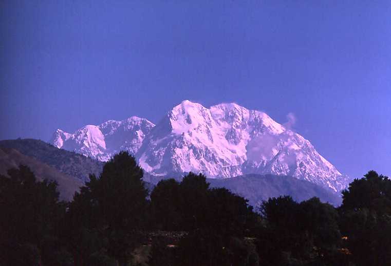
Elevation : 7708 m
Best Climbing Months:

June, July, August

Year First Climbed:

1950

First Climber(s)

Arne Naess,
P Kvern berg,
H. Berg.
Ranking

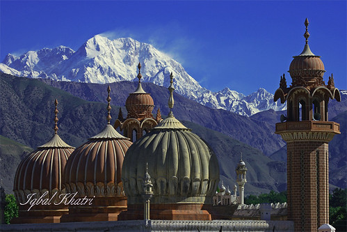
highest Mountain In Hindukush range


Tirich Mir like Rakaposhi and Nanga Parbat to the east, is known for being the home of 'Peris' called "fairies" in english. The Tirich valley parallels the Turikho Valley and is separated from it by a 15 mile-long flat-topped ridge which averages about 12,500 feet in elevation. The ideal way to reach this ridge, for its unsurpassed views of the high peaks in the Hindu Kush, is to climb Zani An (12,500). Zani An is situated between Shagram and a mile higher than Drasan, thus it is most easily approached from the Tirich valley, because the climb is 2,000 feet less from this side.The ridgetop in both directions from the pass is quite level, inviting you to stroll along it and view the spectacular Hindu Kush peaks from Tirich Mir to Saraghrar and north.
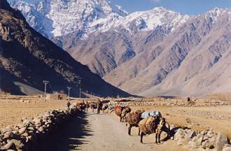
The traditional route to the peak passes through Chitral - Reshun - Kuragh - Khosht - Drassan - Zani pass - Shagram and Shaikh Naik. After a two-hour jeep drive on Chitral-Mastuj road one has to take a direct route from Perpish to Barum village and then through the glacier of the same name (Barum) to the peak. This route is, however, recommended for those who have already acclimatized themselves with high-altitude-climbing; otherwise there is a great danger of high altitude sickness.

Tirich Main peak (7,708m/25,288ft) was climbed for the first time in 1950 by a Norwegian expedition which was lead by Arne Naess. The other members of the expedition included P. Kvern berg and H. Berg. The expedition was also accompanied by Professor Hameed Beg of the Karakoram Club (Pakistan) who reached an altitude of over 6,096m/20,000ft quite a feat in those times. Captain Tony Streather of Chitral Scouts tagged alongwith the expedition from Drosh and eventually climbed Tirich Mir.

The first major attempt by Pakistanis was the Karakoram Club's expedition to Tirich Mir in 1951. The expedition was led by Mian Abdul Rauf and consisted of Daud Beg, Arshad Munir and Captain Shaukat Malik. It set up three advance camps and reached 6,553m/21,500ft before abandoning the attempt due to shortage of supplies.


The first major attempt by Pakistanis was the Karakoram Club's expedition to Tirich Mir in 1951. The expedition was led by Mian Abdul Rauf and consisted of Daud Beg, Arshad Munir and Captain Shaukat Malik. It set up three advance camps and reached 6,553m/21,500ft before abandoning the attempt due to shortage of supplies.

It was in 1982 that a German by the name of Fritz Stammberger tried to climb, all alone, a subsidiary peak of Tirich Mir (7,701 m/25,267ft). He could go up to (6,096/20,000ft) when he was hit by an avalanche and sustained minor head and face injuries. Upon returning to base camp he met an American expedition of Knauth, Peter Newell and Dr. Bill Bartlett from whom he received medical treatment. Tirich Mir (E):- It has a height of 7,692m/25,236ft and was climbed in 1964 by a Norwegian expedition which was again led by Arne Naess, who had headed the successful 1950 Tirich Mir (Main) expedition. Two members, R. Hoibakk and A. Opdal, reached top of Tirich Mir (E). Tirich Mir (West II):- It is about 7,500m/24,607ft high, and was climbed in 1974 by Beppe Re and Guido Machetto of an Italian expedition. After establishing base camp, the party set up two additional camps. In order to acclimatize itself with high altitude climbing, the party also climbed an already-climbed Dirgol Zom peak.

Tirich Mir (West I): Its height is 7,487m/24,563ft. The peak was climbed in 1967 by a Czechoslovak expedition led by Vladimir Sed ivy. It is, however, doubtful whether this was the first ever climb on the peak by this party. The party is stated to have climbed it by the north-west col. J. Cervinka, I. Galfy, V. Smida and I. Urbanovic reached the top. In addition to the above climb, the party made quite a few climbs on other mountains. Some of them were the first-ever climbs.


The fifth highest peak in the Tirich Mir range is Tirich Mir (West Ill) which is 7,400m/24,278ft high. It was climbed in 1974 by Groupe Universitaire de Montagne et de Ski of France and was led by Guy Lucazeau and Bernard Amy. The sixth peak of the Tirich Mir range is Tirich Mir (West IV) - 7,338m/24,075ft. It was climbed in 1967 by Kurt Diemberger and Dietmar Proske through the very difficult north face. Diemberger also made the first circle around the Tirich Mirs. The purpose was to carry-out geological survey of the area. His route passed through Shagram (above Zani pass) Atak Banduk - Shaikh Naik - Tirich glacier - Ano glacier - Lower Gazikistan glacier - Arkari valley - Owir pass - Barum -Lethzom - Atak and back to Shagram.

Another interesting peak in the Tirich Mir range is un-named with a height of 7,100m/23,294ft. This peak is situated to the south of Tirich Mir (Main) peak. It is therefore better to call it Tirich Mir (South). Yet another interesting peak of the range is northern spur of Tirich Mir which is stated to be 7,056m/23,149ft high. It was climbed in 1965 by Kurt Diemberger, Herwig Handler and Fritz Lindner of a German - Austrian expedition.


Tirich Mir (Little) (6,550m/21 ,489ft) can be considered as the last peak in the Tirich Mir range. The peak was attempted by Pak-Karakoram Club expedition in 1951 but was eventually climbed in 1969 by the British-Pak Army Mountaineering expedition which was led by Maj. J. W. Fleming of the British Army. Captain Mumtaz Khan and Lieutenant Azhar Hussain represented the Pakistan Army. The party approached the peak from Chitral via Shogor, Beshgram, Susum, Lasht and Owir pass, Awi and South Barum glacier. Captain M.W.H. Day, Captain R.A. Summerton and Corporal J. Anderson were able to climb the peak. The party indicates its height as 6,361m/20,869ft. Tirich Mir still holds its attraction and lure for enthusiastic.

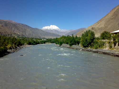
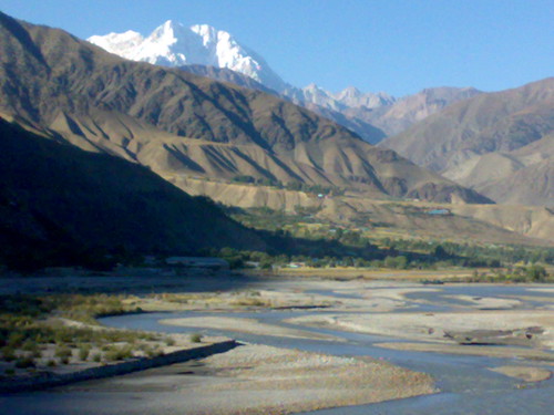
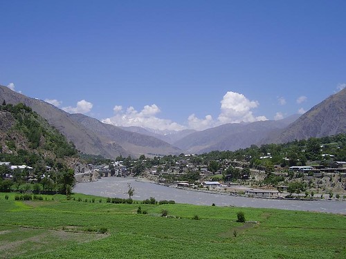
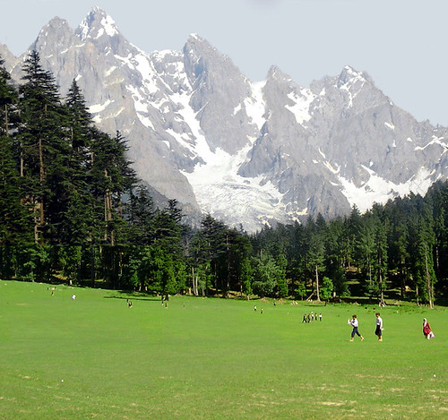
In the last but least Beautiful Scene from Tirich Mir.


Tuesday, April 19, 2011

Kalasha Valleys.

FACT FILE:

Geographical Location:
35°42'18.30"N
71°41'52.73"E
Physical Location:
Northwest in the N.W.F.P province of Pakistan bordering Afghanistan in the Hindukush Range
Total Area:

Altitude:

Best Time to Visit:
May to October


The Kalash or Kalasha, are a Caucasoid ethnic group that lives in the Hindu Kush region of Pakistan. Located in the North-West Frontier Province of Pakistan, the Kalash people live in three isolated mountain valleys Bumboret, Rumbur and Birir.
Their neighbors, the Nuristani call them Kasivo. The Kalash are probably an ancient Dard people who speak the Kalasha-mun language. Many Kalash claim that they are the direct descendants of either Greek settlers, Alexander the Great's army, or even Alexander himself. The climate is typical of high elevation regions without large bodies of water to regulate the temperature. The summers are mild and agreeable with average maximum temperatures between 23° and 27°C Winters, on the other hand, can be very cold, with average minimum temperatures between 2° and 1°C. The average yearly precipitation is 700 to 800mm.

Culture;


The region is extremely fertile, covering the mountainside in rich oak forests and allowing for intensive agriculture, despite the fact that most of the work is done not by machinery, but by hand. The powerful and dangerous rivers that flow through the valleys have been harnessed to power grinding mills and to water the farm fields through the use of ingenious irrigation channels. Wheat, maize, grapes (generally used for wine), apples, and walnuts are among the many foodstuffs grown in the area, along with surplus fodder used for feeding the livestock.
Their unique culture and belief system differs drastically from the various ethnic groups surrounding them. The Kalash believe in various deities Mahadeo (Khodai, the Khowar word for God is also used), and worship other deities that offer protection to different aspects of life (such as Jeshtak, who represents family, pregnant mothers, and marriage). It is suggested that they are based on the Proto-Indo-European religion, similar to the twelve Olympian gods of Ancient Greece. Nature plays a highly significant and spiritual role in their daily life. As part of their religious tradition, sacrifices are offered and festivals held to give thanks for the abundant resources of their three valleys. Presently, these self-sufficient farmers are moving towards a cash-based economy whereas previously wealth was measured in livestock and crops.


They celebrate the Joshi (spring) festival at the end of May each year, which they gauged by the movement of the sun. The first day of Joshi is "Milk Day", on which the Kalash offer libations of milk that have been saved for ten days prior to the festival. Kalash women usually wear long black robes, often embroidered with cowries shells. Men have adopted the Pakistani shalwar kameez, while children wear small versions of adult clothing after the age of four.
In contrast to the surrounding Pakistani culture, the Kalash do not in general separate males and females or frown on contact between the sexes. However, menstruating girls and women are sent to live in the "bashaleni", the village menstrual building, during their periods, until they regain their "purity". They are also required to give birth in the bashaleni. There is also a ritual restoring "purity" to a woman after childbirth which must be performed before a woman can return to her husband. The husband is an active participant in this ritual. Kalash women breastfeed in public. Although some marriages are arranged by families, Kalash boys and girls can also propose and arrange their own marriages.


The Kalash have been ruled by the Mehtar of Chitral since the 1700s and have enjoyed a cordial relationship with the major ethnic group of Chitral, the Kho. The multi-ethnic and multi-religious State of Chitral ensured that the Kalash were able to live in peace and harmony and practice their culture and religion. The Nuristani, their neighbors in the region of former Kafiristan east of the border, were invaded in the 1890s and forced to convert to Islam by Amir Abdur-Rahman of Afghanistan and their land was renamed Nuristan.

Prior to that event, the people of Kafiristan had paid tribute to the Mehtar of Chitral and accepted his suzerainty. This came to an end with the Durand Agreement when Kafiristan fell under the Afghan sphere of Influence. Recently, the Kalash have been able to stop their demographic and cultural spiral towards extinction and have, for the past 30 years, been on the rebound. Increased international awareness, a more tolerant government, and monetary assistance has allowed them to continue their way of life.


Tourism now makes up a large portion of the economic activities of the Kalash. Before departing to the valleys one must first register one's name at the town of Chitral. People attempting to enter the valleys have to pay a toll to the Pakistani government, which they claim will be used to preserve and care for the Kalash people and their culture.
Travelers should refrain from interfering with or patronizing the locals. The villages are more heavily visited by tourists than ever before and the Holy festivals are very serious to them and joining in or gawking at their practices is considered very rude.

Famous festivals:
Joshi or Chilimjush :


14th and 15th of May. During this festival flowers are plucked, dance sessions are held and exchange of dairy products takes place.

Utchal:


Mid July. Celebrated to mark harvest season with dancing, singing and feasting for two days.
Phool:


20th to 25th September to celebrate the ripening of grapes and walnuts. They never touch grapes before this festival.
Chaumont:
Held in December from 15 to 21. This festival is celebrated with great pump and show on the onset of New Year. A number of interesting events mark this festival.
Mrachiwaki Joshi:
25 May Held ten days after the Joshi. After dividing and eating newly made cheese at the altar of Mahandeo, dances and songs continue.
Rat Nat :
July - August. Dancing and singing at night continue for one month.
Uchao:
Mid of August. Newly made cheese is brought from the pastures. Ceremony is held at the altar of Mahandeo. Dancing and singing take place until dawn.
Prechieishi:
November. Goats are sacrificed to Mahandeo by each clan in thanks for the harvest and health.
Biramor:
November.Very rare festival held only in November in which a man wishing to gain honour in the society slaughters many of his own goats and entertains a large majority of the Kalasha. It takes place once in several years.
Sariack:
November - December.Wedding party. She-goats are sacrificed to Jeshtak and prayers are offered for the couple. Dance and songs.
Pu and Budalak;
October. Festival only held in Biriu. Dancing and singing continue for three days. After Pu, grapes are allowed to be harvested. After that, a festival is held for the Budalak who returns from long stay in the pastures. He is a young goatherd who has some special sexual power and privileges.
Accessibility:

The journey from Islamabad and Peshawar to Kalash takes approximately 12-14 hours. It takes about 14-15 hours to reach Gilgit over Shandur Pass.
Pakistan International Airlines has a daily flight between Chitral and Peshawar International Airport. The flying time is approximately 50 minutes and the flight is scenic. These flights, however, are subject to the clearance of weather and in winters, flights are often delayed


Monday, April 18, 2011

Why Pakistan?

Importance of Pakistan according to place.
Pakistan is a country of astonishing beauty and diversity, not to mention clear blue skies, stunning mountains and friendly, courteous people. Pakistan displays some of Asia’s most magnificent landscapes as it stretches from the Arabian Sea, its southern border, to some of the world’s most spectacular mountain ranges in the north. Pakistan is also home to sites that date back to word’s earliest settlements rivaling those of ancient Egypt and Mesopotamia.


Pakistan is a land of infinite options. You can mingle with the crowds in one of the more sophisticated beach resorts or wander through the historic cities like Lahore, Harappa, Moenjodoro. If it’s an activity holiday you’re looking for, Pakistan is one of Asia’s premier trekking and expedition destinations.


Nowhere in the world is such a great concentration of high mountains, peaks, glaciers, and passes except in Pakistan. Of the 14 over 8,000 meters high peaks on our earth planet, four occupy an amphitheatre at the head of Baltoro Glacier in the Karakoram Range: K-2 (8,611 meters, originally called Chogo-ri which in Balti language 'king of the mountains,' of all the world's mountains second only to Mount Everest), Gasherbrum-I (8,068 meters), Broad Peak (8,047 meters) and Gasherbrum-II (8,035 meters). There is yet another, which is equally great, Nanga Parbat (8,126 meters), located at the western most corner of the Himalayas. There are 42 other peaks which are higher than all the highest peaks of the other continents. In addition to that, there are 160 peaks over 7,000 meters and 700 others over 6,000 meters. The Northern Pakistan is also home to some of the longest glaciers outside Polar region; Siachen (72 kilometers), Hispar (61 kilometers), Biafo (60 kilometers), Baltoro (60 kilometers) and Batura (64 kilometers). Besides the high mountains, Northern Areas' longest glaciers including the Godwin Austin, Abruzzin and Baltoro which meet at Concordia forms the largest glacial lake at a height of 4720 meters.Two more ranges, by unique comparison minor in size, thrust their sinews and limbs into the Pamir Knot: the Pir Panjal with its peaks of just over 20,000 feet, and China's celestial mountain, the Kun Lun. Where these ranges merge, they form what many regard as the most impressive landscape that sometime recalls Shangri-La. This concentration makes northern Pakistan a trekkers' paradise.
The enchanting valleys of Hunza, Shigar, Khaplu, Ishkuman, Naltar, Gilgit, Skardu, Chitral, Kalash and the glacial lakes like Kachura, Satpara,Lalusar, and Saiful Muluk add unmatched grandeur to the beauty of the rugged mountains. The Northern Areas with its flora and fauna; the wildlife which can be seen in the form of snow leopards, ibexes and urials; and the variety of people who live in these areas with their diverse cultural heritage and millennia-old civilizations form a paradise for the tourists, trekkers, and mountaineers from all around the world.


You could try your hand at big game fishing or horse riding, learn how to windsurf or water ski. Other unmissable experiences include Qawwali (Pakistan’s answer to soul music), country fairs where centuries-old folk traditions are lovingly reenacted, and mouthwatering Pakistani and Moghul foods. Pakistan is a country ripe for discovery.
Located in South Asia, Pakistan shares an eastern border with India and a north-eastern border with China. Iran makes up the country’s south-west border, and Afghanistan runs along its western and northern edge. The Arabian Sea is Pakistan’s southern boundary with 1,064 km of coastline.


The terrain varies from rugged and mountainous to flat, alluvial plains. Karachi, the largest city in Pakistan, is situated on the shores of the Arabian Sea near the mouth of the Indus.The streets are lively with hundreds of street restaurants, teahouses, samosa and juice stalls. Boats can be hired to sail out of the harbor.
Lahore, is a historic, bustling city with buildings of pink and white marble. There is plenty to see: bazaars, the Badshahi Mosque – one of the largest mosques in the world and an example of Moghul architecture rivaled only by the Taj Mahal.
Islamabad, the capital of Pakistan since 1963, and Rawalpindi, are both located on the Potohar Plain. The old part of the town boasts fine examples of local architecture and the narrow streets are crammed with bazaars where craftsmen are still using traditional methods.