LinkShare_468x60v1

Friday, May 6, 2011

Highest Polo Ground (Shandur Polo Festival) Pakistan.


The world’s Highest Polo Ground


Imaginative overview

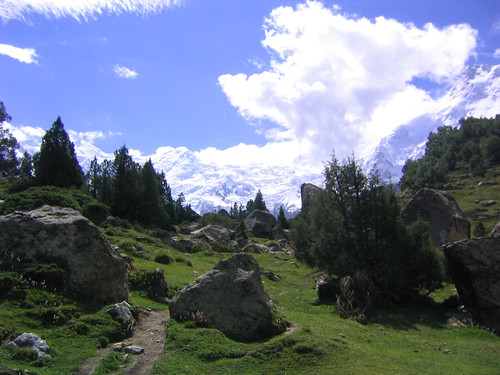
Just for a moment race up your horses of imagination and reach a place where there are the highest mountains around you. There is nothing around you except high peaks and a grassy flat ground beneath you. There are no trees. The sky seems very close to you. You have the feeling that you can touch the sky. There is a light cold breeze blowing. When you inhale the air that does feel so pure and clear. When you look at the grassy ground, an idea comes into your mind. You think that the conditions are ideal for something that would entertain, refresh and introduce you and your place to the world. But what to do? Then you take a view of the culture of the area. The bravery of the people, available resources and traditions inspire you and you think that the place is ideal to have Polo here. Now give a rein to your horses of imagination. Just pack your bag and reach Shandur to have the remarkable memories of your life in the highest polo ground of the world.

History of Polo


Sometimes, imagination leads you to give birth to a big event or festival. It has been the history that the emperors and the rulers have imagined the peace and harmony with such kind beauties and blessings of the nature. Beauty of nature always gives you the soft feelings and games give you the power of decision and bit positive kind of rigidity. Both attributes are necessary to make a real human being. Polo is called the game of games.

Polo has its origin from Central Asia started back in 6th BC. At first it was a training exercise for the cavalry of King’s guards. Initially there were 100 players in each side. It was like a miniature battle. Polo became the national game of Persia (Iran), and then it spread to Arabian countries and later on in Tibet, China and Japan.

Geographical Introduction


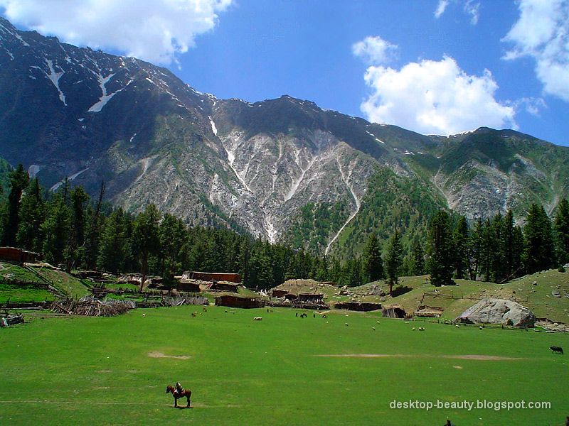
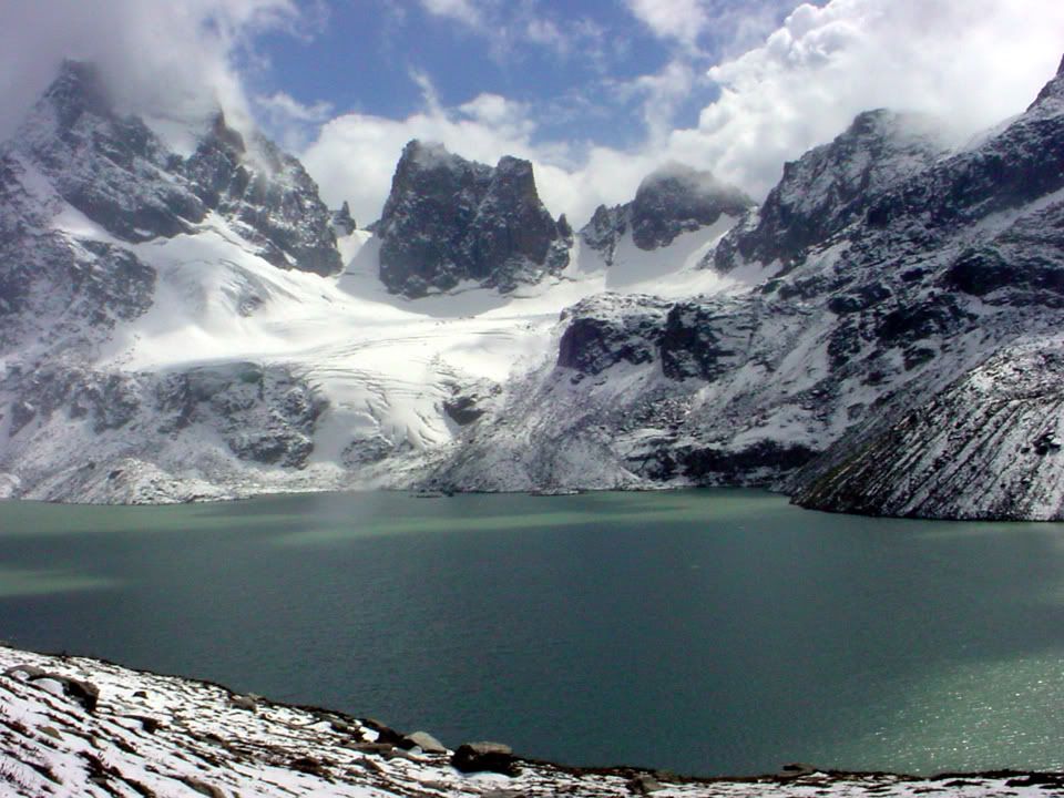
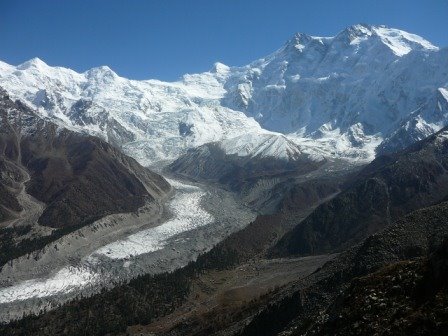
Shandur pass is about 12,200 high above the sea level. It is located in Northern Areas of Pakistan. Shandur is a high mountain pass that connects Chitral to the Gilgit in Pakistan. Pass is a route between mountain ranges. At this place three mountain ranges, Hindukash, Pamir and Karakaram meet. This is the reason why it is called the Roof of the World. The Shandur Pass is flat, a plateau and can be crossed in late April and early November. People of Shandur speak Khowar language.

Shandur Polo Festival

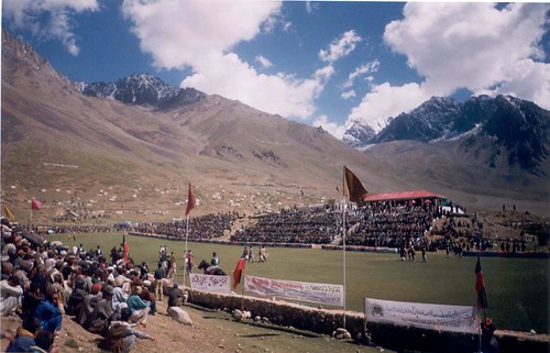
In 1920s, the ruler of Moskuj (a place between Chitral & Gilgit) was told by his King to promote integration within his realm through a polo match among best players. Col Evelyn Hey Cobb, a polo player himself, introduced an idea of having a polo tournament in the Shandur Pass. They decided to have a tournament among the best teams of Chitral and Gilgit. From that day,every year there is a polo tournament played on Shandur Top between rival teams from Chitral and Gilgit. This polo tournament is held in July every year. This is being held since 1936 annually. Shandur polo ground is considered to be the highest polo ground in the world. Except polo there are other festivities like folk music, dancing and camping village are also set up.

Unique about Polo in Shandur

As you have read earlier that Shandur is the highest Polo ground of the world. This is at the height of 12,200 feet. Another thing is that the Polo is played here according to the old ancient rules. Theses are the rules set by the people who originally invented. You will find polo in its purest form here. Interesting about Shandur is that it is a No Tree zone.

Wednesday, May 4, 2011

Fairy Meadows Pakistan

“HEAVEN ON EARTH”


SOME WORDS

Natural beauty is un matched and at its best in northern areas of Pakistan. This part of the country is famous all around the world because of sky high mountains, lush green valleys, mighty rivers, beautiful lakes, and amazing wildlife. In short, you can find all natural beauty in the area. Among the other beautiful places in North Pakistan, there are Fairy Meadows which are famous around the globe for its natural beauty. This is undoubtedly outstanding natural beauty. These meadows are situated at the base of Nanga Parbat in Astore District of Gilgit Baltistan province. Nanga parbat is the 9th highest mountain of the world with elevation of 8,125m. Nanga Parbat is called the Killer Mountain because it is very difficult to climb that’s why is the deadliest mountain in the world. The view of Nanga Parbat is breathtaking from the fairy meadows. Fairy meadows are great attraction for polo lovers, mountaineers, photographers, climbers etc.


This beautiful place is located in front of the North face of the Killer Mountain, Nanga Parbat and at the bottom of the Raikot Glacier. These meadows are located on the south of Karakaram Highway and Indus River. By reaching Raikot bridge there is the journey of one and half hour to reach the point from where you start the journey towards fairy meadows. Then the path becomes narrow and you can not continue traveling by jeeps. The only way to reach the site is hiking. This upward journey takes two and half hours, although it becomes very tiring but you enjoy the beauty at its beast and set aside all other feelings other than the magic of the place. If you want to reach the base camp which is called Beyal camp of Nanga Parbat you have to walk through the beautiful pine forest of the fairy meadows. There are birch trees, beautiful streams and a beautiful lake surrounded by the trees. There are famous fairy meadow cottages. In front of these cottages you will find famous Pari Mahal or Fairy Palace. This name was given by a Japanese photographer Fujita Heroki. This meadow accommodates the most of the visitors who come to see the Nanga Parbat. If you really want to enjoy the beauty of the area and the glory of Nanga Partabt then there is no place other than the fairy meadows. The name, Fairy Meadows was given by an Austrian climber with the name Hermann Buhl. This is the man who climbed the Nanga Parbat for the first time in 1953. Many of the visitors and climbers are of the view that this is the best place to see on earth.


FOR TOURISTS

The place is very tourist friendly. You can find tents and food easily there. Although food is bit expensive but accommodation is available at reasonable rates. But you can cook yourself because meat, pulses and potatoes are available. The best time to visit the are is June-July because you can access the are only in summers. In winters place is closed due to heavy snowfall.

It is truly called heaven on Earth. Get ready and have a beautiful journey to the Fairy Meadows in Pakistan.


Tuesday, April 26, 2011

Heavenly Beauty Pakistan.

Pakistan, A Treasure Trove of Wonders. But we care!
ABBOTTABAD,HAZARA, PUKHTUNKHWA,PAKISTAN.
MAJOR ABBOTT.


Abbottabad is a small neat and clean town in a spacious valley surrounded by green hills. It is a popular summer resort, located at the end of Murree-Abbottabad hill tract at a height of 1,220 meters, noted for its verdant parks, gardens, golf course and pine covered hills. Abbottabad, apart from being famous for its educational institutions and Military Academy, also serves as the gateway to most beautiful places in Pakistan.


Abbottabad is the gateway to the formidable Karakorams, the enchanting Himalayas and the deadly Hindukush. The great Karakurram Highway passes right through the heart of the city. Due to that, Abbottabad continues to be a transit city for tourists. Abbottabad is the junction from where one can go to places like Hunza, Gilgit, Skardu and Indus Kohistan, of the Karakoram Range. One can reach Swat, Swati Kohistan, Dir and Chitral of the Hindukush Range. One can approach Naran, Saif-ul-Muluk Lake, Shogran and Babusar Pass of the Himalayan Range. Neelum, Lipa and Jhelum Valley of beautiful Azad Kashmir are also connected through Abbottabad.


While other hill stations are deserted during winter this place has visitors due to the bracing winter. The place has beautiful gardens, Jinnah Garden, Ladies Garden and another garden maintained by the Cantonment Board. To the splendid stretch of turf with plenty of room for polo, football, hockey and golf. At the back of the station, to the West, is the Brigade Center, ideal for walks and picnic. The Cantonment area of Abbottabad is still very British. The European bungalows, the club, the church and cemetery are still there. Abbottabad is an hour's drive from Nathiagali, the summer capital of the North West Frontier Province, emerging steeply through beautiful valleys with trees right to the riverbed.


Nature Tourism Services

Nature Tourism Services was established in year 1997. Nature Tourism Services are licensed tour operators and are approved by the Department of Tourist Services, Government of Pakistan.Provide services like, package tours, hotel bookings, transport arrangements, event management, seminars and conference arrangement.


Ayubia Chair Lifts.
A cluster of four small hill stations of Khanaspur, Khairagali, Changlagali and Ghora Dhaka is called Ayubia and was named after former President Ayub Khan. The complex is spread over an area of 26 KM. The central place of Ghora Dhaka has Chair Lifts, which gives a panoramic and mesmerizing view of the surrounding. Ayubia is 38 KM from Abbottabad.


Dungagali.


Dungagali is a picturesque small resort situated on the slopes of the Mukshpuri hill (2,376 meters.). It commands a charming view of a series of wooded spurs projecting towards the river Jhelum on the western side. From Dungagali one can climb the 2,813 meters peak of Mukhshpuri, which is the highest point in the range. Natural springs abound on the slopes. It is 34 KM from Abbottabad.

Nathiagali.


Nathiagali is clad in pine, walnut, oak and maple trees, is the prettiest hill resort in the Galliat region. It can be approached both from Murree and Abbottabad. It is 32 KM from Abbottabad as well as from Murree. Nathiagali is 2501 meter above sea level and is surrounded by lush green lofty mountains. Breathtaking landscapes, spring water and fresh air make it one of the most peaceful hill stations in Nathiagali.
Nathiagali is clad in pine, walnut, oak and maple trees, is the prettiest hill resort in the Galliat region. It can be approached both from Murree and Abbottabad. It is 32 KM from Abbottabad as well as from Murree. Nathiagali is 2501 meter above sea level and is surrounded by lush green lofty mountains. Breathtaking landscapes, spring water and fresh air make it one of the most peaceful hill stations in Pakistan.
Thandiani.


Thandiani means “cold” in the local language. Therefore being a cool place it got the name of “Thandiani”. It is 2,700 meters above sea level on a small plateau surrounded by pine forests. This beautiful spot can easily be approached from Abbottabad, and is 31 KM from main Abbottabad City and 25 KM from Thandiani-Nathiagali crossing. The drive takes more or less 80 minutes from Abbottabad with lovely views on both sides of the road. The road rises more than 1,219 meters above Abbottabad. On the way along with tall majestic pine trees you come across groups of monkeys. The major place on the way is Kalapani at 23 KM from Abbottabad. It has a beautiful local Dak bungalow. Hule Ka Danna is about two KM North of Thandiani. It is one of the most beautiful glades in the region.
Thandiani offers lush green lovely views. At night the lights of Abbottabad District and Azad Kashmir are clearly visible. To the East beyond the Kunhar River, may be seen the snow covered mountain ranges of Kashmir, to the North and NorthEast, the mountains of Kohistan and Kaghan are sighted, to the NorthWest are the snowy ranges of Swat and Chitral.

History

Abbottabad was a city of British India, the headquarters of Hazara Division (then a district), and named after its founder, Major James Abbott. Abbott settled this district in 1853 after the annexation of the Punjab, and became its first Deputy Commissioner. It was an important military cantonment and sanatorium, being the headquarters of a brigade in the second division of the northern army corps. In 1901 the population of the town and cantonment was 7764. Before leaving Abbottabad, Major Abbott wrote a poem Abbottabad. Point of interest for Tourism in Abbottabad.
Some Beautiful Places and Buildings in Abbottabad.